Looking for the best scenic drives in Uganda? Here are five real routes with distances, road conditions, and stops — from Lake Victoria to the Rwenzori.
Top Scenic Drives in Uganda
Uganda doesn’t hide its best views behind an entry gate. Some of the country’s most jaw-dropping scenery is free, and it’s right there on the tarmac (and sometimes murram) between your starting point and wherever you’re actually headed. If you’re after the best scenic drives in Uganda, you don’t need a safari package — you need a full tank, good tyres, and a rough idea of where to slow down. Here are five real routes worth the diesel, laid out in the order you’d actually drive them.
1. Kampala–Entebbe Road: Lake Victoria on Your Doorstep
This is the shortest drive on the list, but it’s the one most Ugandans do without realising it’s scenic. The drive from Kampala to Entebbe covers about 43 kilometres, mostly along the Entebbe Expressway, which has cut travel time considerably compared to the old Entebbe Road. Entebbe sits on the shores of Lake Victoria, and the town itself straddles the equator, surrounded by lakeshore forest.
For a proper Lake Victoria fix without leaving the city, detour through Ggaba, about 11 kilometres south of Kampala’s CBD. It’s Kampala’s fishing-village escape — grilled tilapia on the water’s edge, wooden ferries crossing to Bulago and Buvuma. It’s not a long drive, but it’s the easiest way to put the country’s biggest lake right in your windscreen on a Sunday afternoon. [INTERNAL LINK: Best weekend day-trip spots near Kampala]
2. Kampala–Jinja Highway: Mabira Forest and the Source of the Nile
The Kampala–Jinja Highway runs about 80 kilometres and is an all-weather tarmac single carriageway in good condition — one of Uganda’s more reliable long roads. About 45 minutes out of Kampala, the highway cuts straight through Mabira Forest, roughly 54 km from Kampala and 26 km from Jinja, with dense rainforest closing in on both sides of the road for a stretch that feels like driving through a green tunnel.
Push on to Jinja, and you’re at the Source of the Nile — the point where Lake Victoria’s water officially becomes the world’s longest river. This drive works well as a warm-up leg for a longer Uganda road trip, and it’s flat, fast, and forgiving enough for any saloon car.
3. Kampala–Fort Portal Road: Tea Estates and the Rwenzori Skyline
Here’s where the scenic drives in Uganda conversation gets serious. The drive from Kampala to Fort Portal covers roughly 330 kilometres via the main western highway, passing through rolling tea estates and banana plantations before a stretch approaching Fort Portal frames the Rwenzori Mountains — the legendary “Mountains of the Moon” — dead ahead.
Fort Portal itself lies in the northern foothills of the Rwenzori, about 300 km west of Kampala and 50 km north of Kasese town. Continue south on the Fort Portal–Kasese road, a 134 km route running through Rwimi, Hima, and Kikorongo, and the Rwenzori range dominates the entire western horizon — snow-capped on the highest peaks, which is a genuinely strange sight to see this close to the equator. Fort Portal sits surrounded by tea estates on the hilltops with the Rwenzoris as a backdrop, and the town is a natural overnight stop before continuing toward Queen Elizabeth National Park.
4. Kabale–Kisoro Road: The Kanaba Pass and the Virunga Volcanoes
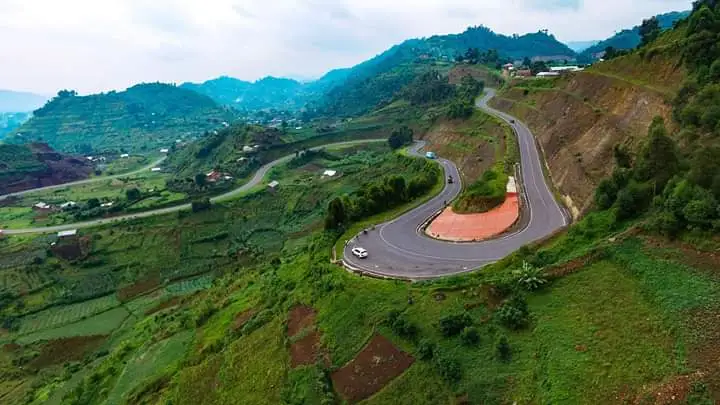
If you only do one scenic drive in Uganda, make it this one. Soon after leaving Kabale, the road passes Lake Bunyonyi, its islands and surrounding hills reflected in calm water, before snaking through high ridges with wide valley views. The road covers a driving distance of about 74 kilometres, taking roughly 1 hour 24 minutes — but budget more, because you will stop for photos.
As you climb toward the Kanaba Pass, the three major Virunga volcanoes — Muhabura, Gahinga, and Sabyinyo — begin to dominate the skyline, their peaks standing against the sky on clear days with clouds often swirling around them. It’s widely regarded as one of the finest views from a road anywhere in East Africa. Roads here are tarmac but narrow and winding, so this is not a route for speed — it’s a route for stopping every few kilometres.
5. Mbarara–Kasese Route: Ankole Cattle Country to the Savannah
Rounding out the loop, the drive from Mbarara toward Kasese takes you through classic Ankole cattle country — rolling green hills dotted with the long-horned cattle the region is famous for — before dropping into the flat savannah approaching Queen Elizabeth National Park. It’s a good contrast drive if you’ve just come off the Kabale–Kisoro highlands, showing you how dramatically Uganda’s landscape shifts within a few hours.
Before You Hit the Road
None of these drives need a hardcore off-roader — most of the tarmac sections here are in decent shape — but a well-maintained vehicle with good ground clearance still makes the Kisoro switchbacks and any murram detours far less stressful. Check automag.ug for road condition updates and driving tips before any long-distance trip. If your current car isn’t quite up to Uganda’s mixed tarmac-and-murram reality, auto24.ug is a good place to look for a dependable second-hand SUV or 4×4. And for drivers thinking about running costs on routes like these — long, fuel-heavy days through the highlands — it’s worth a look at EV24.africa to see where Uganda’s EV import options currently stand, even if charging infrastructure along these particular routes is still catching up.