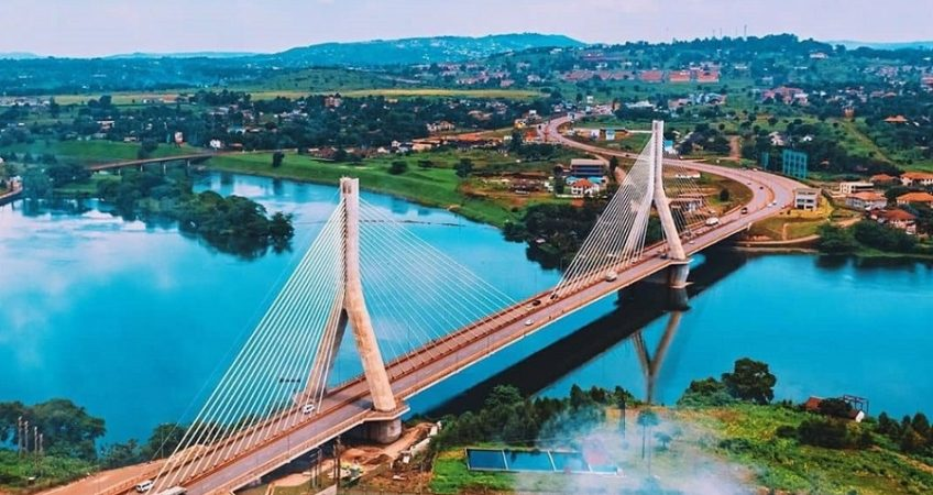
Drive the Jinja to Mbale highway like a pro. Bridges, scenic stops, road conditions, and car care tips for a smooth Eastern Uganda road trip.
Jinja to Mbale Highway Adventure: Bridges, Views, and Stops
There’s something about heading east out of Jinja that feels different from any other drive in Uganda. Maybe it’s the Nile still glinting behind you in the rearview mirror, or maybe it’s knowing that somewhere ahead, Mount Elgon is waiting to fill your windscreen with green. Either way, the Jinja to Mbale highway is one of those routes that rewards patience, a well-serviced car, and a genuine appetite for roadside discovery.
This drive isn’t just a way to get from Point A to Point B. It’s a proper adventure, stitched together by bridges old and new, trading towns bursting with life, and views that make you glad you didn’t fly. Whether you’re a Kampala driver heading to the Elgon region for the first time, or a Mbale local making the return trip, here’s your practical guide to doing this journey right.
Getting Your Bearings: The Route at a Glance
The most common way to cover this stretch is via the Jinja–Tororo Highway to Nakalama (a suburb of Iganga), then branching off onto the Nakalama–Tirinyi–Kamonkoli–Mbale Road, which threads through Namutumba, Tirinyi, and Kamonkoli before rolling into Mbale town. In total, you’re looking at roughly 140–145 kilometres of driving, which typically takes between 2.5 and 3.5 hours depending on traffic through the trading centers and how many stops you make (and trust us, you’ll want to make a few).
This branch road was upgraded to bitumen standard with support from the African Development Bank, and it has since seen further rehabilitation work by the Uganda National Roads Authority (UNRA). That said, like many upcountry roads, sections have historically battled surface erosion and the occasional pothole after heavy rains, so a bit of alertness goes a long way, especially in the wetter months.
Crossing the Nile: Your Journey’s First Big Landmark
Before you even properly leave Jinja, you’ll cross one of the most historically significant points on this route: the bridge over the Nile near the site of the old Owen Falls Dam (now the Nalubaale hydroelectric complex). This is more than a river crossing; it’s a genuine “we’ve started” moment. Take a second, if traffic allows, to appreciate that you’re crossing the world’s longest river at one of its most storied points before the road turns properly eastward.
Car care tip: Before any long-distance trip like this, check your radiator coolant level and inspect for leaks. Bridge crossings and highway cruising put sustained load on your cooling system, especially in Uganda’s midday heat, so a coolant top-up beforehand can save you an awkward roadside wait.
Iganga and Nakalama: The Route’s Commercial Pulse
Iganga town is one of the busiest trading centers you’ll pass through, known for its bustling market and steady flow of trucks heading toward the Kenyan border via Tororo. Just past Iganga is Nakalama, the junction where you’ll leave the main Jinja–Tororo Highway and turn onto the road that takes you north-east toward Mbale.
This junction area can get congested with boda bodas, taxis, and parked trucks, so it’s a good spot to slow down rather than push through impatiently. It’s also a sensible place to grab a quick snack, use a fuel station, or stretch your legs before the next stretch, which has fewer big towns.
Car care tip: Junction towns like Nakalama are notorious for sudden stop-start traffic. Give your brake pads a quick check before the trip; if you’re hearing squealing or feel reduced stopping power, get them inspected before tackling this route, since heavy, unpredictable braking is common through these centers.
Namutumba, Tirinyi, and the Bridges in Between
Heading north-east from Nakalama, the road passes through Namutumba and on to Tirinyi. This stretch has had its share of infrastructure challenges over the years, including reports of bridge and culvert damage from flooding on some of the smaller waterways that cross the road, which UNRA has periodically repaired and reinforced. It’s a reminder that Uganda’s rural bridges, though modest compared to the Nile crossing, are just as vital in keeping this corridor connected during the rainy season.
The scenery through here shifts gradually. Where Jinja and Iganga feel commercial and busy, the land opens up past Tirinyi into farmland, with maize, cassava, and rice paddies stretching toward the horizon. It’s a quieter, greener rhythm, and a good stretch to simply enjoy the drive.
Car care tip: Rural sections with narrower shoulders and occasional loose gravel patches call for good tyre tread. Check tyre pressure and tread depth before departure; underinflated tyres are more likely to suffer sidewall damage on rougher patches of this road.
Kamonkoli and the Approach to Mbale
As you push on through Kamonkoli, you’ll notice the terrain starting to rise gently, and if the sky is clear, your first real glimpses of the Mount Elgon massif begin to appear on the horizon. This is arguably the most rewarding visual stretch of the whole trip. The mountain, one of the oldest extinct volcanoes in East Africa, dominates the skyline as you close in on Mbale, and it only gets more dramatic the closer you get.
Mbale town itself sits at the foot of Elgon, and the final kilometres into town cross the Namatala River area, historically a spot prone to seasonal flooding and past bridge damage during exceptionally heavy rains. Local road crews have worked to reinforce this crossing over time, but it’s worth being cautious here during rainy season travel.
Car care tip: Approaching elevation changes near Mbale, keep an eye on your engine temperature gauge. A car that’s been cruising flat highway for two hours can behave differently on inclines, so ease off rather than flooring it up the gentler rises near town.
Practical Stops Worth Making
A few spots along the way are worth building into your itinerary:
- Iganga town for fuel, snacks, and quick vehicle checks before the branch road.
- Nakalama junction for a short stretch break and to confirm your turn-off.
- Tirinyi trading center for roadside fruit vendors, especially in season.
- Kamonkoli for your first proper photo opportunity of Mount Elgon in the distance.
Choosing the Right Car for This Route
If you’re planning to make this drive regularly, whether for business between Jinja and Mbale or simply for weekend exploring, vehicle choice matters. A car with reasonable ground clearance and dependable cooling performance will handle the mix of good tarmac and occasional rough patches far more comfortably than a low-slung sedan. Popular, reliable options for Uganda’s upcountry roads include the Toyota RAV4 and Toyota Noah, both known for their fuel efficiency and easy access to spare parts locally. To find second-hand cars suitable for these conditions, check out auto24.ug, where you’ll find certified, inspected options like the Toyota RAV4 and other SUVs well suited to routes like Jinja–Mbale.
If you’d rather browse a wider range of listings and negotiate directly with sellers, carkibanda.com is another solid platform for buying a car in Uganda, alongside its steady stream of automotive news and driving tips for Ugandan roads.
For drivers looking to explore sustainable mobility, EV24.africa offers import options for electric cars, expanding choices in Uganda’s growing EV market and giving upcountry travelers a glimpse of what future road trips on routes like this one could look like.
Final Thoughts: More Than Just a Drive
The Jinja to Mbale highway isn’t the flashiest route in Uganda, but it’s honest, scenic, and genuinely rewarding for anyone willing to take it at a sensible pace. Between the Nile crossing at the start and Mount Elgon rising at the finish, it’s a drive that reminds you why road-tripping in Uganda, done right, beats flying every time.
For more travel routes, car care tips, and vehicle reviews tailored to Ugandan drivers, discover additional guides on automag.ug.
Have you driven the Jinja to Mbale route recently? What’s your favorite stop along the way?